
Project Overview
Redshift Media conducted a comprehensive aerial survey of Judy Holt Bushland Reserve — a 25.7 hectare urban bushland reserve in the Redlands region of South East Queensland. The project combined high-resolution RGB photogrammetric mapping with a dedicated thermal wildlife detection program, delivering a complete spatial dataset and fauna presence record across the entire reserve in a single survey program.
The Challenge
Urban bushland reserves face increasing pressure from development, pest species, and habitat fragmentation. Traditional ground-based fauna surveys are time-consuming, expensive, and limited in coverage. Land managers need accurate spatial data and reliable wildlife detection across entire reserves — not just transect samples.
Judy Holt Bushland Reserve presented challenges typical of urban bushland — dense native canopy, varied terrain, and cryptic fauna species that are difficult to detect through conventional ground survey methods. A comprehensive assessment required both precision spatial mapping and systematic fauna detection across the full extent of the reserve.
Phase 1 — Photogrammetric Mapping
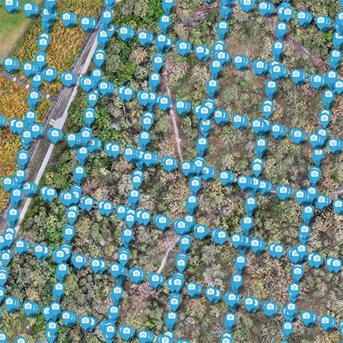
Operating the DJI Matrice 4T — a professional dual-sensor platform carrying simultaneous RGB and radiometric thermal cameras — Redshift Media completed four systematic flight missions across the reserve in a single morning session. High-resolution RGB imagery was captured across the full 25.7 hectare area, providing complete coverage for photogrammetric processing.
All mapping data was processed locally using WebODM, producing a full suite of spatial outputs without the data privacy concerns associated with cloud-based processing pipelines.
Images collected
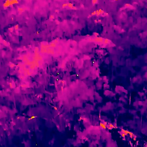
Phase 2 — Thermal Wildlife Detection
A dedicated thermal wildlife detection program was conducted across the reserve over multiple dawn survey flights, taking advantage of optimal low ambient temperature conditions to maximise thermal contrast between the environment and animal body heat.
All survey flights were conducted using DJI low-noise propellers to minimise acoustic disturbance to fauna during detection operations. Survey flights were conducted systematically to ensure complete coverage of all habitat zones within the reserve.
Species Detected
Mapping Results
The 2.0cm ground sampling distance delivers resolution sufficient for individual plant identification, canopy structure analysis, and detailed habitat mapping — well beyond the minimum requirements for most environmental assessment applications.
Area Covered
Images Captured
Images Reconstructed
Ground Sampling Distance
Point Cloud Density
Horizontal Accuracy CE90
Vertical Accuracy LE90
Processing Time
Judy Holt Bushland Reserve Thermal Wildlife Detection Program
Species Detected
Twenty or more individual fauna detections recorded across multiple dawn survey flights. Native species presence confirmed alongside invasive pest species — delivering actionable data for both conservation management and pest control programs.
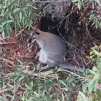

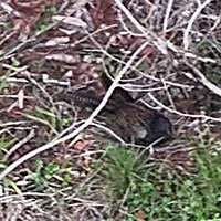
Wallaby & Joey
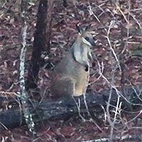

Rock Wallaby

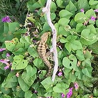
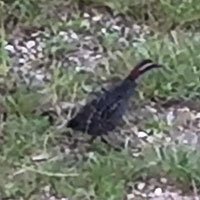
Pheasant Coucal
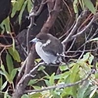

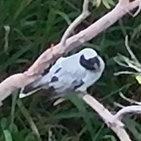
Pied Butcherbird

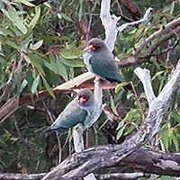
Blue-faced honeyeater

Australian Magpie
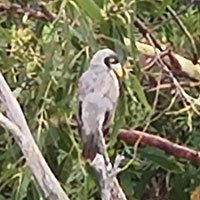

Noisy Miner

Water Dragon
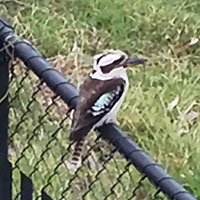

Kookaburra
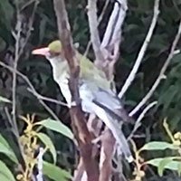

Olive-backed oriole
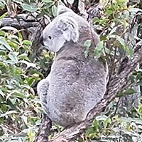

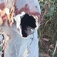
Koala
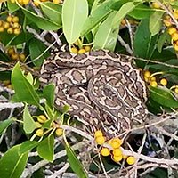

Coastal Carpet Python

Buff-banded Rail*


Rainbow lorikeet
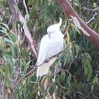

Sulphur-crested cockatoo

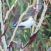
Black-faced cuckooshrike

Oriental dollarbird

Australian Wood Duck*


Spangled Drongo


Red fox
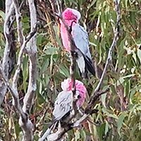

Galah
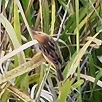

Golden-headed cisticola
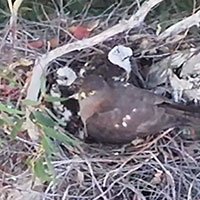

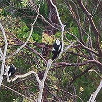
Brown goshawk nest
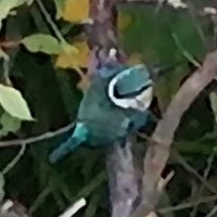

Sacred Kingfisher


Torresian crow
Wildlife Detection
Thermal detection of koala and wallaby within dense urban bushland canopy demonstrates the capability of aerial thermal surveying to reliably locate cryptic species that are difficult or impossible to detect through conventional ground survey methods.
The detection of an active Brown goshawk nest and confirmed Koala presence provides directly actionable data for habitat management and conservation planning.
Pest species detection — particularly the confirmed Red fox presence — highlights the dual application of thermal survey data for both native fauna monitoring and invasive species management programs.
Why This Matters
This project demonstrated that a single licensed operator, properly equipped, can deliver what would traditionally require multiple contractors, multiple site visits, and significantly greater cost and ground disturbance.
The combined photogrammetric mapping and thermal wildlife detection workflow produces a richer, more actionable dataset than either method could deliver independently — spatial accuracy for habitat mapping, and thermal precision for fauna detection, from a single mobilisation and survey program.
For land managers, councils, and environmental consultants, this represents a fundamentally more efficient approach to bushland reserve assessment.
Pest & invasive species detection
A critical component of comprehensive bushland reserve assessment
Invasive pest species represent one of the most significant threats to urban bushland biodiversity. Ground-based detection methods — spotlighting, camera traps, and track surveys — are time-consuming, labour-intensive, and provide incomplete coverage of large or densely vegetated reserves.
Thermal aerial surveying changes this entirely. A single pre-dawn flight can systematically cover an entire reserve, detecting warm-bodied pest species against the cool ground temperature with a level of accuracy and coverage that ground methods simply cannot match.
Red Fox (Vulpes vulpes)
Feral fox presence was confirmed within the Judy Holt Bushland Reserve boundary during the thermal detection program. Foxes represent a severe threat to native ground-dwelling fauna — preying on reptiles, small mammals, ground-nesting birds, and their eggs.
Detection of fox activity within an urban bushland reserve provides directly actionable intelligence for land managers and biosecurity programs. Knowing where foxes are active, and at what frequency, is the first step in designing an effective targeted response.
Why Thermal Detection Works for Pest Species
Feral animals are inherently secretive and primarily nocturnal — making them difficult to detect through conventional survey methods.
Thermal imaging is ideally suited to pest detection because body heat is clearly distinguishable from ambient ground temperature in pre-dawn conditions, systematic aerial coverage eliminates the gaps inherent in ground-based transect surveys, large areas can be covered in a single flight reducing cost and survey time dramatically, and detection data is spatially referenced so you know exactly where animals were detected.
Redshift Media offers dedicated feral and invasive animal detection surveys for councils, conservation landholders, and agricultural operators across South East Queensland.
Mapping Deliverables
Explore the Dataset
This project dataset is available as a fully interactive 3D experience. Measure distances, inspect elevation data, navigate the point cloud, and review individual camera frames — all in your browser.