
3D Spatial Capture
Photorealistic 3D Reality, Delivered to the Browser
Gaussian Splats, Photogrammetry & Reality Capture — South East Queensland
3D spatial capture is the next evolution of visual documentation — moving beyond photographs and video to capture real-world environments, objects, and structures as fully interactive 3D models that anyone can explore in their browser.
Redshift Media delivers professional spatial capture services across South East Queensland using the latest gaussian splat and photogrammetry workflows, processed entirely in-house with no third-party data exposure.
What is a Gaussian Splat?
Gaussian splatting is a recent breakthrough in 3D reconstruction technology — producing photorealistic 3D scenes from regular photography or video that can be viewed and navigated in real time on the web.
Unlike traditional 3D models built from polygons and textures, gaussian splats represent a scene as millions of tiny coloured points that combine to recreate the original lighting, reflections, and fine detail of the captured environment. The result is genuinely photoreal — viewers can orbit, fly through, and inspect captured scenes with a level of visual fidelity that conventional 3D techniques cannot match.
For clients, the practical advantage is simple: anyone can experience the captured space directly in their web browser, on any device, with no specialist software required.
Aerial Spatial Capture
Using the DJI Matrice 4T and Mavic 4 Pro, we capture large-scale outdoor environments — landscapes, properties, heritage sites, industrial facilities, and event venues — for full 3D reconstruction.
Aerial spatial capture delivers a complete photoreal record of a location at a specific point in time, suitable for documentation, planning, marketing, and ongoing reference. Combined with our photogrammetric mapping outputs, clients receive both an interactive 3D experience and survey-grade spatial data from a single capture program.
Suitable for: Heritage and cultural site documentation, large property and estate documentation, industrial and infrastructure recording, event venues and outdoor spaces, environmental and conservation documentation.
Ground & Handheld Capture
Not every project needs a drone. For interiors, vehicles, objects, heritage items, and spaces where aerial access isn't practical, we use professional handheld capture techniques to produce the same photoreal 3D output.
Operating the Sony A1 — a flagship 50 megapixel camera — combined with methodical capture protocols, we deliver gaussian splat and photogrammetric reconstructions of subjects ranging from individual objects to complete building interiors.
Suitable for: Vehicle and motorsport documentation, heritage objects and artefacts, building interiors and architectural spaces, retail and showroom environments, museum collections and exhibitions, insurance and asset documentation.
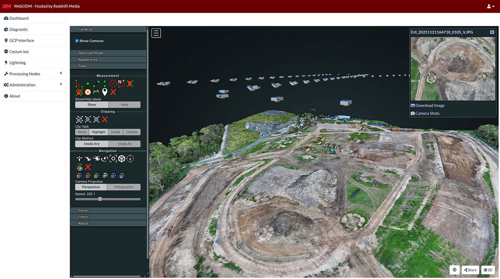
Photogrammetry & Point Clouds
For projects requiring measurable, survey-grade spatial data, we deliver high-density photogrammetric reconstructions and point cloud datasets suitable for engineering, GIS, and CAD applications.
Where gaussian splats excel at visual fidelity and presentation, photogrammetry delivers the geometric accuracy required for measurement, analysis, and integration into existing spatial workflows.
Deliverables include: Dense point cloud (LAS/LAZ), orthomosaic and DSM outputs, mesh and textured models, CAD and GIS-compatible exports, full processing reports with accuracy statistics.
Suitable for: Engineering and construction, heritage conservation, archaeological documentation, environmental assessment, asset management and infrastructure.
Browser-Based 3D Delivery
Every spatial capture project is delivered as an interactive online experience — accessible directly through a web browser on any device, with no software installation or specialist hardware required.
Clients receive a private, secure link to their dataset where they can orbit, navigate, measure, and inspect the captured environment at their own pace. Share the link with stakeholders, embed it in presentations, or integrate it into existing documentation workflows.
For clients requiring full control, datasets can also be delivered as standalone files for offline use, archival, or integration into other systems.
In-House Processing — Your Data Stays Yours
All spatial capture processing is conducted on Redshift Media infrastructure. Your imagery, your scenes, and your reconstructed datasets are never uploaded to third-party cloud services, never used for training external AI models, and never accessible to anyone outside your project.
For commercial, government, and sensitive heritage projects — this matters.