
RPA Services
RPA Services Professional Remotely Piloted Aircraft Operations
Licensed CASA Commercial Operator — South East Queensland
Redshift Media operates under full CASA commercial licensing as a certified RPA operator, delivering precision aerial imaging services across South East Queensland. Every mission is conducted with professional-grade equipment, comprehensive public liability insurance, and strict data security protocols.
Aerial Photography & Video
From construction progress to real estate, events to infrastructure — if it needs to be seen from above, we can capture it.
Operating the DJI Matrice 4T and Mavic 4 Pro, we deliver high-resolution stills and 4K aerial video for commercial, industrial, and creative applications. Every shoot is planned and executed with full CASA compliance, airspace authorisation, and risk assessment.
Suitable for: Construction & infrastructure documentation, real estate & development, events & media coverage, marketing & promotional content, industrial site inspection.
Thermal Wildlife & Fauna Surveys
Accurate fauna detection across entire reserves and land parcels — from a single mobilisation.
Using the DJI Matrice 4T's radiometric thermal sensor, we conduct systematic dawn survey flights to detect fauna presence across bushland, grassland, and riparian zones. Thermal imaging detects body heat signatures through dense canopy cover, locating cryptic species that conventional ground surveys routinely miss.
Our survey program at Judy Holt Bushland Reserve detected 27 species across multiple dawn flights — including koala, swamp wallaby, kangaroo with joey, active gosshawk nest, and invasive pest species — across 25.7 hectares of urban bushland.
All survey flights are conducted using DJI low-noise propellers to minimise acoustic disturbance to fauna during detection operations.
Deliverables include: Species presence record with thermal detection stills, annotated flight coverage map, summary report suitable for environmental assessment, GIS-compatible spatial data on request.
Suitable for: Pre-clearance fauna assessments, bushland reserve monitoring, habitat mapping and conservation planning, council and government environmental programs, ecological consultants requiring detection data.
Feral & Invasive Animal Detection
Know what's on your land. Target your response. Protect your livelihood.
Feral animals cause billions of dollars in damage to Australian agriculture annually. Feral pigs destroy crops and pasture, contaminate water sources, and spread disease. Foxes devastate livestock and native wildlife. Wild dogs, feral cats, and rabbits compound the problem across vast areas that are impossible to monitor effectively on foot or horseback.
Thermal drone surveys change the equation. A single pre-dawn flight can cover hundreds of hectares, detecting feral animal presence, movement patterns, and population concentrations with a level of accuracy and coverage that ground-based methods simply cannot match.
Target species: Feral pigs, foxes, wild dogs & dingoes, feral cats, rabbits, and any other invasive species present on your land.
Suitable for: Graziers and broadacre farmers, horticulture and viticulture operations, conservation landholders, local governments and biosecurity programs, pest management contractors requiring detection data.
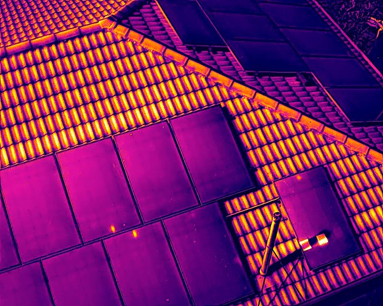
Thermal Inspection
Radiometric thermal imaging for infrastructure, buildings, and assets — delivering calibrated data, not just colour pictures.
The Matrice 4T carries a fully radiometric thermal sensor, meaning every pixel contains actual temperature data. This is the difference between a thermal camera that shows you pretty colours and a calibrated instrument that tells you exactly how hot something is.
Applications include:
Solar Panel Inspection Identify underperforming cells, hot spots, bypass diode failures, and delamination across entire arrays in a fraction of the time required for ground-based inspection. Delivered as annotated thermal reports with GPS-tagged fault locations.
Building Envelope Assessment Detect moisture ingress, insulation failure, thermal bridging, and air leakage in commercial and industrial buildings.
Electrical Infrastructure Identify overloaded connections, failing components, and thermal anomalies in switchyards, transmission infrastructure, and industrial facilities.
Suitable for: Solar farm operators and installers, commercial and industrial property owners, facility managers and building surveyors, engineering firms and insurance assessors.
Visual Asset Inspection
Close visual inspection of structures, assets, and infrastructure — without the cost or risk of scaffolding, rope access, or elevated work platforms.
The DJI Matrice 4T's integrated zoom camera delivers sharp, detailed imagery at distance — allowing methodical inspection of assets that are difficult, dangerous, or expensive to access conventionally. Every inspection is captured as a geotagged, timestamped visual record suitable for maintenance planning, insurance assessment, and compliance documentation.
Applications include:
Roof & Building Inspection Detailed visual assessment of commercial and industrial roofing, facades, guttering, and structural elements. Identify damage, deterioration, and maintenance requirements without access equipment.
Tower & Antenna Inspection Telecommunications towers, transmission infrastructure, and elevated assets inspected safely and efficiently from the air.
Bridge & Civil Infrastructure Visual condition assessment of bridges, retaining walls, drainage infrastructure, and civil assets — delivered as a complete photographic record with GPS-tagged fault locations.
Marine & Coastal Assets Jetties, pontoons, seawalls, and coastal infrastructure inspected without vessel access requirements.
Deliverables include: Full resolution geotagged inspection imagery, annotated condition report, GPS-tagged fault or defect locations, before/after comparison documentation for repeat inspections.
Suitable for: Asset managers and facility managers, local councils and government infrastructure teams, insurance assessors, civil and structural engineers, telecommunications operators, marina and port operators.

Mapping & Photogrammetry
Survey-grade spatial data from aerial capture — processed entirely in-house with no cloud data exposure.
Using the DJI Matrice 4T's high-resolution RGB sensor and processed through our local WebODM installation, we deliver precision mapping outputs suitable for engineering, environmental, and land management applications.
Our Judy Holt Bushland Reserve dataset achieved 2.0cm ground sampling distance across 25.7 hectares — with horizontal accuracy of 1.4cm CE90 and a 240 million point dense point cloud.
Deliverables include: Orthophoto mosaic (GeoTIFF), Digital Surface Model (DSM), Digital Terrain Model (DTM), contour data, dense point cloud (LAS/LAZ), volume calculations, full quality report with accuracy statistics.
Suitable for: Engineering and construction, land management and vegetation monitoring, environmental assessment, council infrastructure and planning, mining and resources.